Previous Projects
The DBRC has taken on numerous projects over the past years. Below are some examples of the work we have participated in, which may be relevant to a project you are planning to undertake. If you have a project in development, check our staff page for contact details so we an discuss any data management or mapping needs your project may require.
Contents:
- Devon Ancient Woodland Inventory Review
- Dawlish Warren NNR
- Cannock Chase SAC
- Conservation Communities
- Fursdon Estate Surveys
- Grand Western Canal Macrophyte Survey
- Green Minds
- Lympstone – Wotton Brook Aerial Survey and Mapping
- South Devon Water Vole Project
- Chudleigh Wild UWS
- Landscape to Legacy
- Nature Recovery Networks
- Networks for Nature
- River Sid
- Life on the Verge
- Active Neighbourhoods Project
- Connecting The Culm
- Wildcat Mapping – Devon Wildlife Trust
Devon Ancient Woodland Inventory Review
As part of a national initiative driven by the Woodland Trust and Natural England, DBRC formed a large county partnership to fund the review of the ancient woodland inventory in Devon.
Over a period of three years between 2019 and 2023, DBRC systematically mapped and researched all woodlands above 0.25 ha in Devon with continuous presence since 1880. As a part of this process DBRC utilised the latest datasets and technology, alongside robust historical evidence, thousands of aerial photo images, maps and text from archives, and 500 surveys to complete this project, reviewing over 25,000 parcels of woodland.
The revised woodland inventory will underpin planning and policy decisions county wide for years to come, protecting this natural and irreplaceable asset for future generations.
We would like to thank our funders and project partners, without whom this review would not have been possible.
Please note that any queries or submissions regarding the ancient woodland inventory should now be sent to Natural England as the controllers of the Ancient Woodland Inventory. DBRC retains no ability to alter or input to the Ancient woodland Inventory now that the review has concluded.
Devon Nature Recovery Networks
During the last 12 months, DBRC has led on the technical development of the Nature Recovery Network mapping in Devon, on behalf of a broad partnership. The overall project is being driven by Devon Wildlife Trust, and Devon County Council, with support from local authorities, conservation NGOs, statutory agencies and a range of stakeholders. Whilst the mapping forms a central part of the project, other strands will include ensuring that appropriate community and landowner support, and information is accessible. The success of this project will rely on people and businesses engaging from all sectors, across the county, and whilst some areas of the national framework are still in their infancy, the forthcoming Environment Bill, will further focus effort in Devon, and within the UK. You can visit the Devon LNP website for more information.
Dawlish Warren National Nature Reserve vegetation mapping (2019)
In 2019 DBRC were commissioned by Teignbridge District Council to undertake a vegetation survey and rare plant species monitoring work which manages part of this internationally important wildlife site. The sand spit is subject to a unique set of pressures arising from the combination of natural coastal processes and high visitor numbers. In 2017, under the Dawlish Warren Beach Management Scheme (DWBMS) much of the hard engineering was removed from the sand dune system and a ‘beach recharge’ undertaken in order to allow parts of the site to function in a more naturally dynamic way.
This survey addressed the need to gain a better understanding about changes in distribution of important species and habitats on site. Some such changes are part and parcel of a dynamic dune system and others – both positive and negative – are the result of impacts from recreational use. There are rare species present at Dawlish Warren which depend upon a certain level of trampling to maintain the right habitat conditions and others that are sensitive to the impacts of erosion and nutrient enrichment. Our survey acts as a baseline following the DWBMS and identify human impacts on habitats and key botanical species for future management.
Cannock Chase SAC – Footpath Extent Assessment Project (2014)
Whilst DBRC predominately undertake project work within the county or in partnership with other regional Local Records Centres, on occasion our skills are required within national projects or in trialling techniques in one-off situations. During late 2013 and early 2014 DBRC were commissioned by a partnership including one of our own partners Natural England, and Staffordshire County Council.
Cannock Chase Special Area of Conservation (SAC), located within the Cannock Chase Area of Outstanding Natural Beauty between the towns of Stafford, Rugeley and Cannock, is designated for its dry and wet heathland habitats. Evidence based assessment for Local Plan preparation by Districts and Boroughs in the southern part of Staffordshire has demonstrated that the SAC habitats are suffering adverse effects from recreation. There is an extensive footpath network and observation and experience of site managers indicated that widening of paths and creation of new paths are resulting in habitat loss and increased fragmentation of heathland blocks.
The Local Authority partners required robust evidence to support preparation of a mitigation strategy that would be funded by developer contributions where residential development is permitted within a recreational zone of influence likely to contribute additional recreational pressure on the SAC.
DBRC were engaged to use aerial photo analysis to;
• Provide information on trends in effects of recreation use on Cannock Chase SAC, with specific regard to paths, tracks and firebreaks, and;
• Provide a baseline for future monitoring of recreational impacts on the SAC as demonstrated through the path, track and firebreak resource.
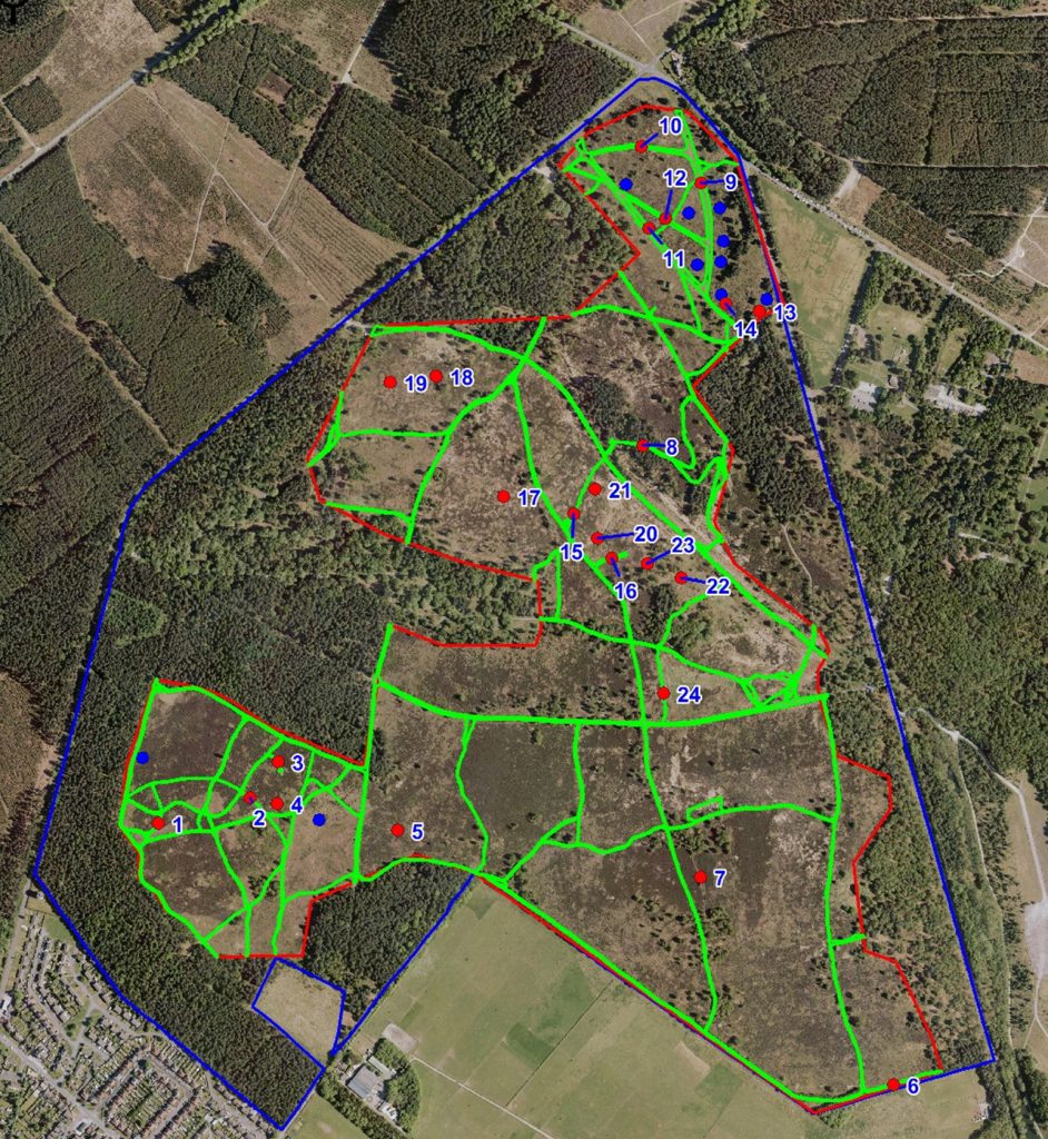
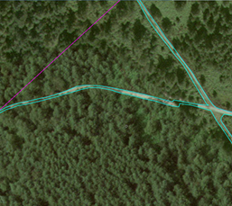
Side by side images of one of the outputs of the Cannock Chase Project. On the left is an overview of the site, including the mapped pathways and target notes. On the right is a close-up of one of the captured pathways with it’s boundaries precisely captured by DBRC staff. ©DBRC
Connecting the Culm Project – Blackdown Hills AONB
DBRC spent three years between 2019 and 2022 leading on biodiversity monitoring of the connecting the culm project in order to aid with the post-intervention monitoring of target sites. The project aims to work with communities and stakeholders within the catchment to identify and define a range of nature-based solutions which can increase the flood resilience of those areas. Protecting housing and infrastructure as well as people, as we move forward in an uncertain climate change scenario. The catchment rolls downhill from the mire habitats at the top of the Blackdown Hills, through mid-Devon and into the National Trust Killerton Estate, where flat grassland rich agricultural land prevails.
DBRC provided training and support to the volunteers involved in surveying these habitats in order for the to be able to identify a range of key indicator species. These indicator species provide vital intel on the condition and functionality of the habitat. We measured carbon capture as part of an international citizen science project, feeding into a wider global project, and supporting partners in designing a legacy which included upskilling those communities, making them more able to participate in future schemes.
DBRC’s Phil Sansum training a group of volunteers for the Connecting the Culm project on how to identify key Culm Grassland indicator species. ©DBRC
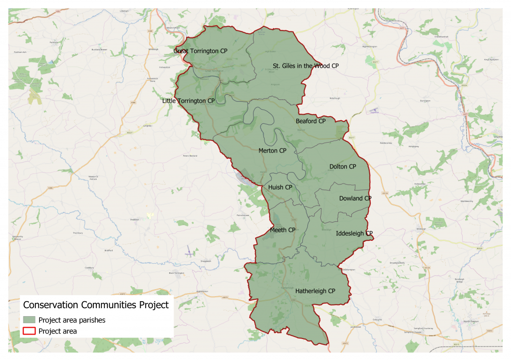
Conservation Communities Project – DWT/DBRC:
This project built on many years of landscape-scale work in North Devon by both of our organisations, including the development of biodiversity audits by DBRC for numerous parishes within the NIA project. In October 2019 we secured funding through the National Lottery Heritage Fund, to work in 11 of those parishes, supporting local residents and community groups to get involved in a range of biodiversity led initiatives, which greatly improved our collective understanding of the species and habitats there.
Residents attended a range of training workshops, walks and talks, and alongside local experts, individuals and volunteer groups were supported in a range of nature-based activities. This included setting up long term monitoring of indicator species, such as otters and dormice, sharing knowledge on nature-friendly verge management, pond creation and improving access to nature for local residents. You can find out more at the project website.
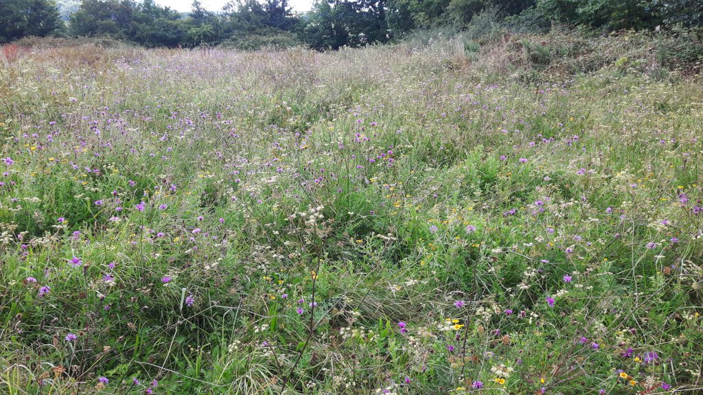
Fursdon Estate – Grassland and Woodland Surveys
Supporting the DWT Working Wetlands team, DBRC undertook a range of surveys within this rural estate. Home to historic parkland and veteran trees, the landscape there also supports a number of unimproved grassland sites, all rich in biodiversity and vitally important within such a heavily modified farming landscape, such as Mid Devon. Our surveys were designed to asist with the estates efforts to plan restoration areas, and work alongside the DWT team to increase water quality in the streams and river nearby.
Grand Western Canal Macrophyte Survey
In the summer of 2023, DBRC were commissioned to undertake a survey of aquatic plants within the canal, to assist in the ongoing management program of this rich biodiversity resource in Mid Devon.
Whilst canals are seen as static waterways, there are still a number of vectors through which invasive plants can get into their systems, and other challenges associated with the surrounding land and its management/use. It’s therefore important to monitor the flora of the canal to indicate its condition and direction of travel, which can include certain species becoming too dominant and out competing others. The canal is home to a vast array of invertebrates, mammals and bird species, and the balance that exists between these and the demands placed upon it by recreational use need careful consideration.
Green Minds – DWT/Plymouth City Council
Following on from several community based green space initiatives by the city council and DWT, this European funded project worked within a wider partnership. It aimed to breathe new life into a number of community spaces, ranging from traditional parks to strategic green corridors, increasing peoples enjoyment, and understanding of the nature benefits good management with local input can bring. DBRC will be monitoring sites, alongside citizen science elements developed with local residents. Training and mentoring were designed to enable interested individuals and groups to be supported in learning about species and habitats, and how they can be protected and have increased resilience into the future. If you would like to learn more about the project, you can visit the project website here.
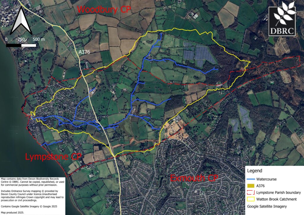
Lympstone – Wotton Brook aerial survey and mapping
In 2025, the DBRC drone team was contracted to collate aerial photographs at key locations along the Wotton Brook catchment in Lympstone in order to assist Lympstone flood resilience group with mapping potential sites for natural flood mitigation. As part of our work, we also produced a number of maps to help the project communicate the extent of the catchment.
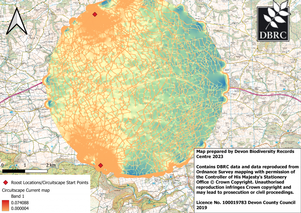
Networks for Nature
Working for Highways England, and in partnership with DWT & Animex, DBRC utilised its data holdings to model areas within our counties A road network. We targeted areas where significant species mortality, pinch points in connectivity (their movement through the landscape) and other challenges occur, due to these routes and associated traffic/infrastructure. Using modelling techniques which include Habitat Suitability Mapping and Landscape Fragmentation/Connectivity mapping, we were able to help identify areas where interventions may have a positive impact. These may include culverted underpasses, green bridges, tree planting or other techniques.
South Devon Water Vole Project
Grant funding from Devon Environment Foundation and South Devon AONB enabled DBRC to investigate a possible return of water voles to a small area of South Devon. Water voles were once common in our waterways, but were declared extinct in Devon in 2002. In recent years, some very limited introductions have been returning this iconic and highly threatened species to our landscape.
This pilot project aimed to identify the potential distribution of water voles within a discreet area of South Devon, initially working with a small number of landholders on targeted surveys. The team also worked to provide training and support to develop volunteer water vole surveyors in the face of challenging conditions due to C19 in order to help the pilot develop into a wider project.

Chudleigh Wild UWS Project – Teignbridge DC & DWT
This was a collaboration between DBRC, Chudleigh Wild (a local group of residents with a passion for wildlife!) Teignbridge District Council and the Devon Greater Horseshoe Bat Project. Like many parishes Chudleigh has some really important habitats, many of which are owned privately, and range from large farmland sites to smaller less used pockets of land. These sites may not be specifically managed for wildlife, but do provide the habitats many species found in this area rely on. For example, grassland sites and woodland fringes, are critically important for the greater horseshoe bats which live in Chudleigh.
DBRC worked with a small group of experienced botanists who live locally, and together with our surveyors hoped to get permission to survey some of the 60 Unconfirmed Wildlife Sites already highlighted as having great potential. Where survey could take place sites meeting the CWS criteria could be designated, recognising their importance both locally and nationally as havens for wildlife.
Landscape to Legacy Project – East Devon AONB
Over two years DBRC used aerial photograph interpretation to identify and map important habitats in the project area. This work provided vital intelligence on the landscape value for multiple species, including the grey long eared bat which is found locally in low numbers. Whilst a predominately desk based exercise, DBRCs team of experienced surveyors can also feed ground truthing data into project, where there are overlaps with our other projects. In this case our work on CWS monitoring was able to dovetail, as was other work in the wider landscape. The resulting data has been able to add to DBRCs knowledge and evidence base, with which it supports its partners, communities and decision making in the county.
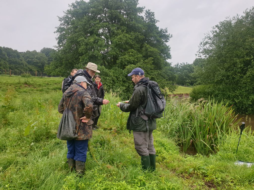
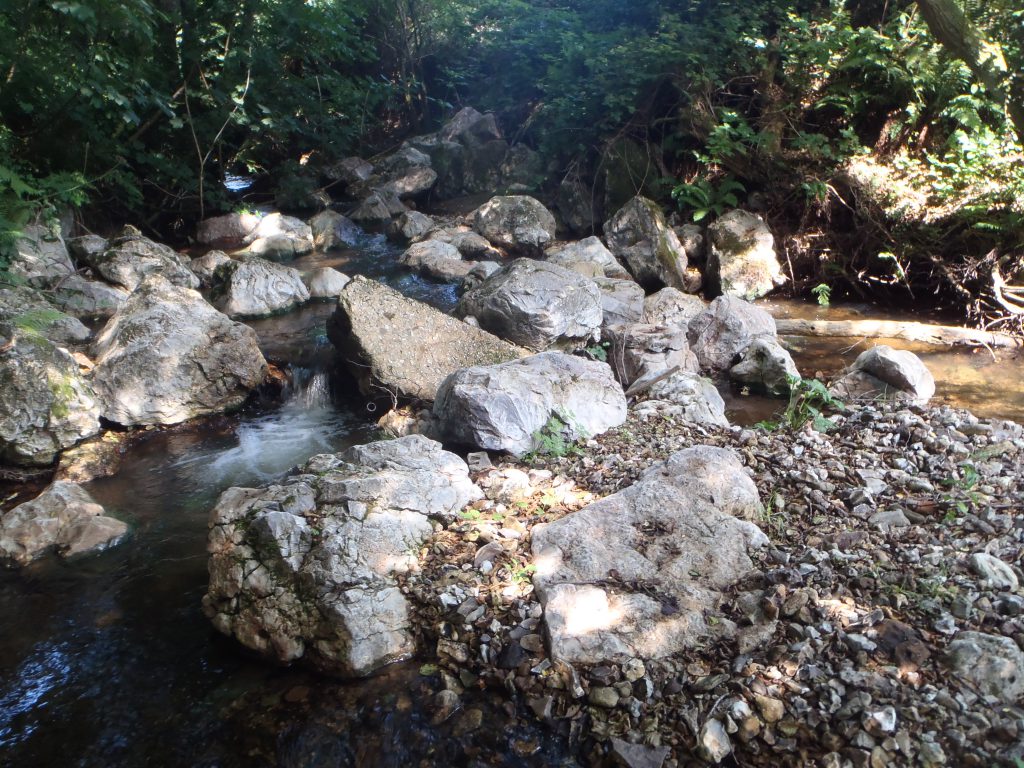
River Sid Project – Devon Wildlife Trust & The Sid Vale Association
During July to September 2013/14, in times of good weather when the water level was low, and the water clear, DBRC staff were able to provide botanical survey support for this project. River corridor surveys require three people with focus on both of the river banks and within the watercourse itself. Scott West, the DWT Rivers Officer focussed on invertebrate surveys and where possible, carried out some electrofishing surveys. Subsequently DBRC were able to produce maps for the surveys, based on the original maps from the 1990s but with an OS map base. Aerial photos were also used where applicable to assist in the survey. The work concentrated on the Roncombe Stream and Snod Brook, as well as the River Sid. Predominately identifying areas for future enhancement or additional focus, the project liaised with numerous landowners and officers from the Sid Vale Association to help create future management plans for these watercourses.
Life on the Verge Project/Tarka Country Trust
Road verges are an important wildlife resource and an integral part of Devon’s heritage. They provide a range of habitats and are increasingly important wildlife corridors for threatened species and pollinators. They also provide one of the only opportunities for us to see wildflowers on a daily basis, in towns and villages, as well as in a largely intensively managed countryside.
DBRC provided a series of workshops for local communities in the project area who are interested in managing their ‘Special Verges’. These workshops included training in botanical plant ID skills, and associated data recording which will allow residents to monitor these habitats as well as input into their future management.
‘Special verges’
There are 15 verges in the Biosphere Reserve that have previously been identified as ‘special verges’ which were all re-surveyed as part of the project, but also hoped to survey more than just these. After survey, with the help of volunteers, selected verges that aren’t currently as diverse as they could be, or at risk of deterioration, will be enhanced by simple management techniques (click here for Plantife’s Good Verge Guide).
The project partners included the North Devon Biosphere and Devon County Council, and it is hoped that this pilot project can have a wider influence within Devon in the years to come.
http://www.tarkacountrytrust.org.uk/love-b.html
Active Neighbourhoods Project/DWT Plymouth
Active Neighbourhoods was a joint project with Plymouth City Council, and employed an Urban Ranger who actively worked with local communities to improve access and understanding of a number of key green spaces in the city
DBRC provided bespoke training opportunities for these communities, and baseline survey of sites without existing biodiversity information.
Volunteer friends groups were set up and supported to develop improvement and management plans for these areas. The project team worked with friends groups, partners (such as Plymouth Public Health and Plymouth Community Homes) and local people to deliver these plans.
Improvements highlighted included better access paths, more welcoming entrances and signage, along with more seating. Plans will also be drawn up with local residents aimed at making the spaces better for local birds, bats, bumblebees, butterflies and other wildlife.
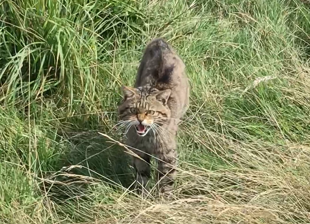
Wildcat Feasibility Mapping – Devon Wildlife Trust
DBRC was contracted by Devon Wildlife Trust to produce potential species distribution maps over the summer of 2024 as part of the wider project studying the feasibility of a wildcat reintroduction in Devon. The aim of this work was to identify potential areas with habitat conditions that are potentially suitable for a Wildcat release in order for further surveys to be carried out.
To do so we produced habitat suitability maps that highlighted areas that match the requirements for a population to establish. DBRC also combined multiple datasets in order to identify potential hazards and opportunities across Devon for any reintroduction attempts to provide further insights on potential release locations.
DBRC continues to find ways to utilise our data to derive new products to aid nature’s recovery in Devon.