Current Projects and Surveys
Devon Biodiversity Record Centre manage and participate in a wide range of projects year on year. With funding in shorter supply across the environmental sector the value we can add to projects has increased. Our desktop mapping and analysis skills can help target conservation efforts more effectively. If you are developing a project, discuss your data management or mapping needs with us at this early stage so that adequate funding is included in your bid.
These are some of the current projects we are working on. Some of these are annual projects, whereas others are long term multi-year projects.
Contents:
- Biodiversity Monitoring Framework
- Devon Wildlife Trust Drone Surveying
- East Dartmoor Landscape Recovery Area
- Finding Natures Footprint
- Great Crested Newt Project
- Living Dart – Salt Marsh Project
- Moor Meadows Partnership
- Nature Recovery Networks
- Networks for Nature
- Saving Devon’s Treescapes
- South West Peatland Partnership
- Tamara Landscape Partnership
- Wildcats Habitat Suitability Mapping
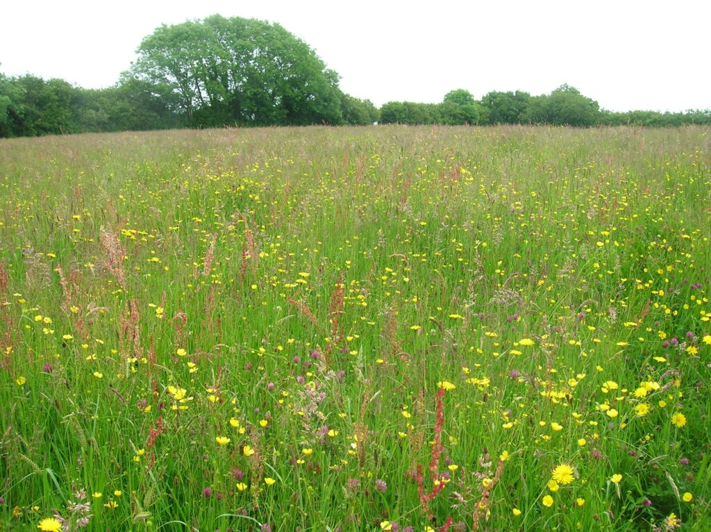
Moor Meadows Partnership
During the course of 2024 DBRC collaborated with Moor Meadows, a community movement dedicated to the conservation, restoration, and creation of wildflower meadows. Our aim was to trial a range of tools and methodologies which would allow landowners to undertake surveys of their wildflower meadows, big or small, well established, or just taking root. Focusing in year one on a small patch of Dartmoor, with the help of those landowners that participated, we were able to learn from that experience, and create a support package which includes on line resources, training sessions, and talks and guides.
Moor Meadows has a wealth of experience within its existing members, and provides information on how to manage these sites, signposts to the best resources available, and ensures an ongoing support network can help guide people on their way to restoring this important habitat for so many of our threatened species.
As a result of the pilot phase, our joint partnership is now able to launch the Big Meadows Count 2025 – The Big Devon Meadows Count 2025 – Moor Meadows
DBRC field team will provide a number of in field training sessions, but also online guidance, with the hope that those that are skilled, or not so skilled can all take part. Species rich grassland had been one of our biggest loses since the 1940’s, with the vast majority of our grasslands being intensively managed nowadays, this habitats is now no more than 1% of the UK land use. Landowners can help us create a far better understanding of how this habitat is fairing in Devon, how much of it exists, and if any of these sites can be recognised further for their quality, by being designated as a County Wildlife Site.
Biodiversity Monitoring Framework
Many of our most important wildlife sites or areas of priority habitat aren’t statutorily designated, for example within a Site of Special Scientific Interest (SSSI), but are identified within a non-statutory framework run by DBRC in partnership with Devon Wildlife Trust and Devon County Council.
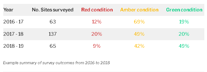
Since 2009, DBRC has led a county-wide monitoring program focusing on these County Wildlife Sites (CWS), where we aim to resurvey sites approximately every 10 years. However, some CWSs have not been revisited since their initial designation in the early 1990s due to a lack of resources for resurvey by the project, or changes in ownership which means we cannot contact the landowners. However, DBRC has now seen more than 1000 sites since the project started, and the results of the surveys help us keep track of changes to our landscape at a fine resolution, and report on the state of our environment in Devon.
There are over 2000 CWS, totalling over 30,000 hectares of land (5% of Devon) this equals the area protected within statutory sites, however, we also have a similar amount of potential sites which have yet to be surveyed and designated. Its vitally important that these sites are seen periodically, as they are representative of what’s happening to our biodiversity landscape, and can act as a barometer for climate change, the efficacy of changes in policy, and in our understanding of nature’s resilience to change.
Due to the scale of the challenge, and to try to increase the number of sites we are collecting information on, this year we have also started to work with community volunteers within a number of parishes. These volunteers already have a degree of expertise, but DBRC is providing additional training and support, so that their local knowledge, contacts, energy & enthusiasm can help us to survey and map some of the most valuable sites within their area. Whilst designating more CWS is a primary focus of this collaboration, in many cases the knowledge that areas of priority habitat exist will be just as important. Mapping these habitats will allow DBRC to include them within the developing Nature Recovery Network project, and provide a better picture of how Devon is fairing against the current challenges to our biodiversity.
Making links with existing groups is key, and their expertise and efforts can add greatly to the work our own surveyors can undertake. The ‘Action for Teignbridge’ (ACT) Wildlife Warden scheme is a prime example of where this collaboration can work effectively. DBRC has suppoted the growth of the group, supplying resources and specialist skills, which will help around 20 of their volunteers undertake surveys of one form or another. It also allows for skills sharing and an increase in understanding of the need to record biodiversity, so that that evidence can support decision making, locally, regionally, and nationally.
We hope to expand this approach year on year, and already have a number of parishes in South and East Devon that we hope to start working with next season. If your parish would like to engage with this initiaitive, and would like to find out more feel free to contact either Jack Rivers- jrivers@devonwildlifetrust.org or Ian Egerton – iegerton@devonwildlifetrust.org.
Tamara Landscape Partnership project
After a highly successful development phase, this project has now been granted its main funding grant, and over the next few years will deliver a range of cross cutting, historical & natural environment, and social/enterprise initiatives. These will help increase the areas resilience to climate change, and its ability to rise to the economic challenges many sectors locally, currently face.
The project is funded through the New Heritage Lottery Fund and offers the partnership the opportunity to focus on elements such as farming and land management challenges, alongside flooding, access, enjoyment of the landscape, its increased resilience, and nature, alongside the historic environment. In addition, it will work with local businesses and traditional micro initiatives such as Tamar Grow Local, which seek to create jobs and investment in the Tamar Valley, by harnessing just one of the valleys long-established, but often undervalued strengths.
DBRC are central to many of the biodiversity sub-projects, providing ecological skills, biodiversity data gathering and management resources, and existing data and evidence. Our first task has been to undertake habitat audits of four of the Nodal Farms, that are partnering the project. This is through a mix of remote sensed aerial photo interpretation of the land holdings, liaising with the landowners to identify focus areas, and ground-truthing through field based survey. These baselines will then help each holding plan any interventions and monitor changes through the extent of the project, as re-surveys are planned in the final year. Click here to visit the project website.
Devon Nature Recovery Networks
During the last 12 months, DBRC has led on the technical development of the Nature Recovery Network mapping in Devon, on behalf of a broad partnership. The overall project is being driven by Devon Wildlife Trust, and Devon County Council, with support from local authorities, conservation NGOs, statutory agencies and a range of stakeholders. Whilst the mapping forms a central part of the project, other strands will include ensuring that appropriate community and landowner support, and information is accessible. The success of this project will rely on people and businesses engaging from all sectors, across the county, and whilst some areas of the national framework are still in their infancy, the forthcoming Environment Bill, will further focus effort in Devon, and within the UK. You can visit the Devon LNP website for more information.

Networks for Nature
Working for Highways England, and in partnerhsip with DWT & Animex, DBRC will be using its data to model areas within our counties A road network, where significant species mortality, pinch points in connectivity (their movement through the landscape) and other challenges occur, due to these routes and associated traffic/infrastructure. Using modelling techniques which include Habitat Suitability Mapping and Landscape Fragmentation/Connectivity mapping, we will be able to help identify areas where interventions may have a positive impact. These may include culverted underpasses, green bridges, tree planting or other techniques. We are just about to start the project and more information will be available as its progresses.

Finding Natures Footprint – North Devon Coast National Landscape
This NHLF project runs over three years, and aims to better connect local communities and nature, through a range of supported activities, training sessions, and annual bioblitz. It hopes to enhance our collective knowledge of the areas wildlife, and fill some of the gaps in the information that we currently hold. As a project partner, DBRC are providing survey training to the project team, as well as support for annual Bioblitz, and other events. You can find more information on the project website.

East Dartmoor Landscape Recovery Area Project – DWT & Partners
DBRC is providing in field botanical survey and monitoring of 27 sites within the project area, helping to gather baseline information. Using our skilled survey team, and existing data and knowledge, we are able to help the project lead to target where within the area their efforts are best deployed. As this development phase will hopefully build into a 20 year land management initiative, its important to be able to measure changes, and monitor the effectiveness of any interventions. More information can be found on the project webpage.

Great Crested Newt project
Great Crested Newts are widespread in many parts of the South East of the country, but by the time you get down to Devon, we are at the very edge of their western range. The population is spread out and under recorded, and back in 2009/10 to help afford them better protection, a number of consultation zones were set up. Within those areas developers must take more consideration of this species, due to potential GCN presence.
However, many of those zones are underpinned by increasingly historic data, and may lose their relevance within planning forums. DBRC have gained funding to revisit up to 60 of the 90 records within Devon, using eDNA testing to secure up to date information on the presence of GCN. This data will be used to update the consultations zones, and where new records are found, either extend existing zones or create new ones. DBRC will be working with local communities to gather information on ponds and suitable grassland habitats within target areas, and increasing understanding of the species needs.
This project is funded by a grant funder, DBRC, the East Devon National Landscape and in partnership with Sirescreen Scientific.

DWT Drone Surveying
Aerial photos are a vital tool for reserve management, however existing satellite imagery like google earth has its limitations. That is why, over the past two years, DBRC has started mapping Devon Wildlife Trust Reserves using our DJI Mavic Enterprise drone, creating high quality aerial maps at a resolution of 2cm at ground level.
These high-resolution images will be used across the reserves for many purposes, including producing baseline condition assessments, carbon monitoring calculations and tracking pathogens such as ash dieback. By producing high quality baseline images, we can ensure that the monitoring of any long-term changes to the reserves are easily identified.
Aerial photography and mapping is just the start for DBRC, as we continue to develop new techniques and data streams from our drone and improve our knowledge of the state of Devon’s Nature.

Saving Devon’s Treescapes
Led by Devon Wildlife Trust with support from National Lottery funding, the Saving Devon’s Treescapes project aims to address the continued threats of diseases like ash dieback, climate change, and evolving land practices on the wider landscape. The project focuses on practical, community-led initiatives, to support both individual species and the broader ecosystem. As a key partner, the Devon Biodiversity Record Centre (DBRC) plays a pivotal role by providing our expertise to support community science and technical aspects of the project.
At present the DBRC has provided lichen identification sessions and brown hairstreak monitoring workshops for the public, to provide communities with the necessary skills to record species. As lichens and brown hairstreaks are heavily reliant on trees, such as ash, their continued monitoring will provide valuable insights into trends arising from the loss of trees, but also the positive actions from projects such as Saving Devon’s Treescapes. DBRC’s involvement has also provided essential technical support by collating, managing, and analysing ecological data. This includes the development and maintenance of the SDT app, analysis of bat call data, and mapping of species data recorded throughout the project.

South West Peatland Partnership – Peatland Restoration Vegetation Monitoring
In autumn 2023, the DBRC partnered with the Southwest Peatland Partnership (SWPP) to deliver detailed vegetation monitoring at peatland restoration sites spanning Bodmin Moor, Dartmoor, and Exmoor. The aims of this long-term project are to establish baseline vegetation data facilitating future analyses on restoration impacts, particularly focused on hydrological changes using vegetation data as a reliable proxy.
Operating in remote and diverse landscapes, the DBRC’s field team utilized their botanical survey experience and knowledge to train both staff and volunteers in the identification and recording of species of upland mires and heaths. Mixed teams of volunteers, DBRC surveyors and SWPP staff are using this knowledge to conduct detailed vegetation transects across restoration areas. During monitoring the DBRC also contributed to the refinement of survey methodology to ensure consistency and repeatability for future surveys.
By providing expertise and technical support in the future, it is hoped that the DBRC will support the SWPP to cultivate a motivated and skilled group of volunteers to revitalise the previous peatland monitoring programme that ran between 2006-2019.

Living Dart – Salt Marsh Project
Salt marshes are incredibly important carbon stores, burying more carbon per unit than terrestrial forests outside of the tropics. Although often overlooked, the Dart estuary still contains small pockets of salt marsh throughout its banks. The Living Dart project is a partnership of the Bioregional Learning Centre, Then Environment Agency, the South Devon National Landscape (AONB), Dart Harbour Authority and Devon Wildlife Trust. It aims to identify, monitor, and ultimately enhance these areas, fostering community connections, supporting biodiversity, and delivering essential ecosystem services.
As a partner of the project the DBRC began in the autumn of 2023, to locate, record and assess existing patches of salt marsh vegetation throughout the Dart estuary. This involves interpreting aerial photography, ground-truthing sites, and employing vegetation monitoring techniques to identify the communities and species present and assess the ecological condition of the habitats found.
The data derived from DBRC’s survey work is being used to inform partners’ approach to delivering the wider project’s objectives around salt marsh restoration and conservation and awareness raising.

Devon Wildlife Trust – Wildcat Feasibility Mapping
DBRC was contracted by Devon Wildlife Trust to produce potential species distribution maps over the summer as part of the wider project studying the feasibility of a wildcat reintroduction in Devon. The aim of this work was to identify potential areas with habitat conditions that are potentially suitable for a Wildcat release in order for further surveys to be carried out.
To do so we produced habitat suitability maps that highlighted areas that match the requirements for a population to establish. DBRC also combined multiple datasets in order to identify potential hazards and opportunities across Devon for any reintroduction attempts to provide further insights on potential release locations.
DBRC continues to find ways to utilise our data to derive new products to aid nature’s recovery in Devon.
